


Hotels
loading map - please wait...
Howard Johnson® By Wyndham Oceanfront Plaza Hotel | |
Howard Johnson® By Wyndham Oceanfront Inn | |
Days Inn® By Wyndham Oceanfront |
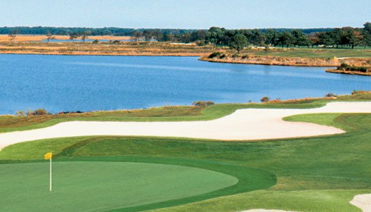
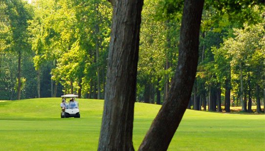
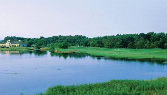
Golf Courses
loading map - please wait...
Heritage Shores | |
The Rookery | |
Baywood Greens | |
Bear Trap Dunes | |
The Links at Lighthouse Sound Golf Club and Community | |
Ocean Resorts Golf Club | |
Glen Riddle | |
Eagle's Landing | |
Rum Pointe Seaside Golf Link | |
Ocean City Golf Club | |
Nutters Crossing Golf Club | |
Nassawango Golf Club |
Road Directions to Ocean City
From the New England Area:
From the New England states, take I-95 South, to the New Jersey Turnpike, and the Delaware Memorial Bridge. Shortly after toll for bridge, take exit for Rt. 13 South (Dover/Norfolk). In Dover, DE, take Rt. 113 South. From Rt. 113, take Rt. 90 East into Ocean City.
From New York State/Canada:
Take I-81 South, through New York, to Harrisburg, PA. In Harrisburg, take I-83 South to the Rt. 695 West (Beltway) around Baltimore, MD. Take Rt. 695 to Rt. 97 South to Annapolis, MD. Follow signs for Bay Bridge to Rt. 50 East. Take Rt. 50 east to Rt. 90 East, into Ocean City.
From the Great Lakes Region:
Take I-70 East to the Baltimore, MD area. From I-70, take the Rt. 695 "Beltway" Southeast to the Glen Burnie area, and Rt. 97 South. Take Rt. 97 South to Rt. 50 East (Annapolis & Bay Bridge). Take Rt. 50 East to Rt. 90 East, into Ocean City.
From the South:
Take I-95 North to Rt. 58 East, in Emporia, VA. From Rt. 58 East, follow signs for Chesapeake Bay Bridge Tunnel and Rt. 64 East. Take Rt. 64 East to Rt. 13 North & Bay Bridge Tunnel (toll). Follow Rt. 13 North to Pocomoke City, MD, and Rt. 113 North. Take Rt. 113 North to Rt. 90 East, into Ocean City.
From New York, New Jersey & Philadelphia:
Take I-95 South to Wilmington, Delaware. In Wilmington, take Rt. 13 South to the Rt. 1 Bypass just north of Smyrna. There is a one dollar toll fee. Taking the bypass around Dover, Delaware avoids many red lights and heavy traffic. At the end of the bypass you will be on Rt. 113 South. Take Rt. 113 South all the way through Delaware. About 5 miles after you cross the Maryland/Delaware line, you take Rt. 90 East. This brings you right into the middle of Ocean City at 62nd St.
From the Washington D.C. Area:
Take Rt. 495 (the D.C. Beltway) around Washington to Rt. 50 East, Exit #19. If you think of the Beltway as a clock, Exit #19 would be at 3 o'clock. Take Rt. 50 East all the way to Ocean City. Rt. 50 ends at the Atlantic Ocean.
From the Baltimore Area:
Take Rt. 695 (the Baltimore Beltway) around Baltimore to Rt. 97 South, Exit #4. If you think of the Beltway as a clock, Exit #4 would be at 6 o'clock. Take Rt. 97 South to Rt. 50 East. Stay on Rt. 50 East all the way to Ocean City. Rt. 50 ends at the Atlantic Ocean.
From the Central Pennsylvania/Harrisburg Area:
Take Rt. 83 South to the Baltimore Beltway 695. You enter the Beltway at Exit #24. If you think of the Beltway as a clock, Exit #24 would be at 12 o'clock. Take Rt. 695 West to Rt. 97 South, Exit #4 (that would be at 6 o'clock). Take Rt. 97 South to Rt. 50 East. Stay on Rt. 50 East all the way to ocean City. Rt. 50 ends at the Atlantic Ocean.
From Pittsburgh:
Take Rt. 76, the Pennsylvania Turnpike, east to Breezewood, PA. Pick up Rt. 70 East. Take Rt. 70 East to the Baltimore Beltway Rt. 695. You enter the Beltway at Exit #16. If you think of the Beltway as a clock, Exit #16 would be at 9 o'clock. Travel South on the Beltway to Rt. 97, which is Exit #4 (this would be 6 o'clock on the Beltway). Take Rt. 97 South to Rt. 50 East. Stay on Rt. 50 East all the way to Ocean City. Rt. 50 ends at the Atlantic Ocean.
Road Directions to Local Courses
The Bay Club
From Route 50 Bridge: Approximately 7 miles west of Ocean City, turn left on Rt. 818 (Main St., Berlin); follow 1.5 miles and turn right on Broad Street (Atlantic Hotel). Follow 1.5 miles to Bay Club entrance on left.
From Route 90 Bridge: Approximately 6 miles west of Ocean City, exit Route 90 to Route 113 South (left turn). Follow 3 miles to Route 50 West. Follow Route 50 West for 200 yards and turn left on Route 818 (Main St., Berlin); follow 1.5 miles and turn right on Broad Street (Atlantic Hotel). Follow 1.5 miles to Bay Club entrance on left.
From Route 113 (Southbound): At intersection of Route 113 South and Route 50 West, take Route 50 West. Follow for 200 yards and turn left on Route 818 (Main St., Berlin); follow 1.5 miles and turn right on Broad Street (Atlantic Hotel). Follow 1.5 miles to Bay Club entrance on left.
The Beach Club
From Route 50 Bridge: West on Route 50, 7.5 miles to Route 113. Exit North on Route 113 (towards Dover) and proceed 1 mile to where the 4 lane highway merges to two lanes. Make U-turn and proceed south on Route 113, 50 yards to Deer Park Drive
From Route 90 Bridge: West on Route 90, 7 miles to Route 113. Exit Route 113 South (towards Berlin); 2 miles to Deer Park Drive (on right).
From Route 113 (Southbound): Two miles past Route 90 overpass. Right turn on Deer Park Drive (shortly after highway becomes dual).
Deer Run Golf Club
From Route 50 Bridge: West on Rt. 50 for 11 miles to Logtown Rd. (mile marker 131). Turn left onto Logtown Rd. to Greenfields' entrance.
From Route 113: Take Rt. 113 South to Rt. 50 West. Follow Rt. 50 West for 2.5 miles to Logtown Rd. (mile marker 131). Turn left onto Logtown Rd. to Greenfields' entrance.
From Route 90 Bridge: Take Rt. 90 West to Rt. 113. Turn left onto Rt. 113 South to Rt. 50 West. Follow Rt. 50 West for 2.5 miles to Logtown Rd. (mile marker 131). Turn left onto Logtown Rd. to Greenfields' entrance.
Eagle's Landing
From Route 50 Bridge: Located 3.5 miles from downtown Ocean City. Head West on Route 50 and make a left onto Route 611 (Golf Course is adjacent to the Ocean City Municipal Airport). Turn left on Eagle's Nest Road.
From Route 113 (Southbound): At intersection of Route 113 and Route 50, turn right (East) towards Ocean City. Approximately 7 miles east at intersection of Route 50 and and Route 611 turn right (follow signs to Assateague State and National Parks). Left turn past airport into Eagle's Landing.
Green Hill
From Route 50 Bridge: Take Rt. 50 West and go through Salisbury to Nanticoke Rd. (Route 349). Take a left. Go approximately 8 miles until you see a sign for Grene Hill (Whitehaven Road), you can only turn left. On Whitehaven Rd., go 1 mile and you cannot miss the golf course! Takes approximately 40 minutes.
From Route 90 Bridge: Head west until you reach Route 50. Follow above directions.
Lighthouse Sound
From Route 50: East on Route 90. Turn left on St. Martins Neck Road. Go approximately 1 mile. Clubhouse on right.
From Route 113: East on Route 90. Turn left on St. Martins Neck Road. Go approximately 1 mile. Clubhouse on right.
From Ocean City: West on Route 90. Turn right on St. Martins Neck Road. Go approximately 1 mile. Clubhouse on right.
Nutters Crossing
From Route 50 Bridge: Take Route 50 West to Route 13 South (Norfolk). Go approximately 3 miles south to Exit Route 12 (Snow Hill). Turn left and go .6 of a mile to Nutters Crossing on the right.
From Route 90 Bridge: Take Route 90 West into Route 50 West. Stay on Route 50 West until you reach Route 13 South (Norfolk). Go approximately 3 miles south to Exit Route 12 (Snow Hill). Turn left and go .6 of a mile to Nutters Crossing on the right.
Ocean City Golf & Yacht Club
From Route 50 Bridge: Go west on Route 50 to third traffic light and turn left (Route 611). Wendy's is on right. Go 6.25 miles (south on Route 611) to the "Y" in the road. Bear right onto South Point Road. Golf course is 1 mile on the right.
From Route 90 Bridge: Head south on Coastal Highway until you get to Route 50 and follow the directions above.
From Route 113 (Southbound): At intersection of Route 113 South and Route 50 turn East onto Route 50 towards Ocean City. Turn right at intersection with Route 611 (approximately 7 miles). Follow signs to Assateague State and National Parks until reaching the "Y" in the road. Bear right onto South Point Road. Approximately 1 mile on the right.
Pine Shore Golf
From Route 50 Bridge: Take Route 50 to Route 589 North (Racetrack Road). From Route 589, make a right turn onto Beauchamp Rd. Pine Shore is located 1/4 of a mile on the left.
From Route 90 Bridge: Take Route 90 to Route 589 North (Racetrack Road). Follow Route 589 down to Beauchamp Road and take a right. Pine Shore is located 1/4 of a mile on the left.
From Route 113: Follow Rt. 113 Southbound until intersection with Rt. 589. Left turn (eastbound) toward Ocean Pines. Approximately 1.5 miles, turn left on Beauchamp Rd. Left turn to course.
River Run Golf Course & Community
From Route 50 Bridge: Take Route 50 to Route 589 North (Racetrack Road). From Route 589, make a right turn onto Beauchamp Rd. River Run is located 3/4 of a mile on the left.
From Route 90 Bridge: Take Route 90 to Route 589 North (Racetrack Road). Follow Route 589 down to Beauchamp Road and take a right. River Run is located 3/4 of a mile on the left.
From Route 113 (Southbound): At intersection with Route 589, turn left towards Ocean Pines. Approximately 1.5 miles on Route 589 to Beauchamp Road. River Run is located 3/4 of a mile on the left.
Rum Pointe
From Route 50 Bridge: Go west on Route 50 to third traffic light and turn left (Route 611). Wendy's is on right. Go 6.25 miles (south on Route 611) to the "Y" in the road. Bear right onto South Point Road. Take your first left onto Rum Pointe Road.
From Route 90 Bridge: Head south on Coastal Highway until you get to Route 50 and follow the directions above.
From Route 113 (Southbound): At intersection of Route 113 South and Route 50 turn East onto Route 50 towards Ocean City. Turn right at intersection with Route 611 (approximately 7 miles). Follow signs to Assateague State and National Parks until reaching the "Y" in the road. Bear right onto South.